
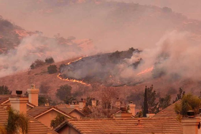
When a wind-driven brush fire starts on the city’s edge, minutes—not hours—decide outcomes; that is why the Hawk Fire’s overnight expansion to roughly 10,500 acres with zero containment and the rapid cascade of evacuations around northwest Reno matter far beyond a day’s headlines.
At a Glance
- Hawk Fire grew to about 10,500 acres with 0% containment during its initial run, prompting widespread evacuations in northwest Reno and the North Valleys.
- Nevada’s governor declared a state of emergency to mobilize resources and reinforce local response as homes and infrastructure came under threat.
- Authorities issued “go now” orders across multiple neighborhoods, opened shelters, and urged residents to leave immediately if directed.
- Airport and highway operations were disrupted; Reno-Stead Airport closed and segments of U.S. 395 saw closures as the fire advanced.
What happened: a fast, urban-adjacent fire run into Reno’s north and west
Originating near the Peavine area and moving rapidly on strong southwesterly winds, the Hawk Fire transitioned from a wildland ignition to an urban-interface emergency in hours, extending to roughly 10,500 acres and remaining 0% contained during the early operational period. Multiple outlets reported the expansion in near-real time as evacuation footprints widened across named neighborhoods from Somersett and Stead to Golden Valley, Lemmon Valley, Cold Springs, and corridor segments along North Virginia Street; “go now” orders included Raleigh Heights to Red Rock and specific road grids like Hoge and Stoltz west of North Virginia, with the Bonanza Terrace RV Park among the earliest high-concern zones. State and local guidance emphasized immediate compliance with orders and warned residents not to impede first responders. While precise acreage counts varied by update time—a normal artifact of evolving perimeter mapping—the central facts held: rapid spread, a large and growing evacuation zone, and zero containment during the critical first operational cycle.
The scale of displacement risk was tangible. The U.S. Forest Service estimate that approximately 1,000 homes were threatened anchored early situational awareness, even as the number of households under evacuation orders and warnings climbed into the tens of thousands across the broader footprint, a reminder that “threatened structures” and “ordered to evacuate” are distinct metrics that often move on different clocks. Public shelters and information lines stood up quickly; the Reno-Sparks Convention Center opened to evacuees as neighborhood-by-neighborhood orders expanded. Aviation and transportation were not spared: fire growth forced Reno-Stead Airport to close and prompted intermittent highway closures as suppression and law enforcement units managed traffic and access.
Why the response escalated: risk, mechanism, and exposure
The logic behind a decisive emergency posture in Reno is straightforward. A wind-aligned brush fire moving through Great Basin grasses and shrublands can project embers far ahead of the flame front, turning highway verges and ornamental landscaping into ignition targets. Reports described the fire’s advance toward and across U.S. 395, an event that compresses travel options for evacuees even as it complicates responder ingress. In this context, Governor Joe Lombardo’s state of emergency was not symbolic; it was the legal and operational switch that aligns state agencies, streamlines mutual-aid logistics, and frees emergency managers to push resources where they will most affect life safety. That posture also underwrites public messaging with the right tone: a clear, unambiguous ask to leave now when told, because minutes matter in a fire that is spotting and doubling back with wind shifts.
The zero-containment reading in the first hours is also mechanically unsurprising. “Containment” is not a measure of effort; it is the percentage of the fire’s perimeter that has a control line expected to hold under forecasted conditions. During a wind-driven initial run, containment frequently sits at 0% while incident commanders concentrate on life safety, evacuation, and point protection—triaging structures at risk and establishing anchor points for later line construction. That sequencing aligns with how large-fire situation reporting is structured nationally; acreage moves first with mapping, then containment follows as lines are built and tested.
Evacuations, shelters, and the number problem: three different metrics moving at once
Early wildfire coverage often compresses three numbers—acres burned, homes threatened, and households ordered to evacuate—into a single storyline, yet each answers a different question and updates on a different cadence. Acres track perimeter mapping; “threatened” structures depend on modeled and observed fire spread into built environments; evacuation counts reflect human geography and law-enforcement decisions to clear neighborhoods before access narrows. In Reno, these metrics diverged quickly: media cited approximately 1,000 homes threatened via federal and county estimates even as the tally of households under evacuation orders swelled, and total acreage marched upward with new mapping passes. Understanding the distinction prevents a common error: treating a larger evacuation footprint as evidence that earlier threatened-structure counts were wrong, when in fact both can be right, just describing different facets of risk.
Shelter operations reflected this dynamic. The Reno-Sparks Convention Center opened while other facilities reached capacity, a textbook pivot from an “initial staging” model to higher-volume reception as orders expanded across the North Valleys and northwest Reno. Authorities paired those moves with standard guidance: heed “go now” directives without delay, leave gates unlocked if instructed, and do not return until officials clear reentry. That messaging is not bureaucratic boilerplate; it is the operational hinge that keeps evacuation traffic flowing one way while engines, tenders, and ambulances move the other.
Infrastructure and mobility: when the fire meets the grid
Two infrastructure facts shaped risk and response. First, airport operations: as the Hawk Fire advanced, Reno-Stead Airport closed—both a safety decision and a way to deconflict airspace for suppression aviation, which includes air tankers and rotorcraft tasked to support line building and point protection. Second, highway and local road closures: U.S. 395, the spine of north–south mobility for the area, saw targeted shutdowns and lane restrictions as the fire pressed east of Peavine and into neighborhoods along North Virginia Street. These moves protect evacuees and responders but also alter evacuation timing; residents farther out who leave early effectively create capacity for those closer in who must wait for an order.
How to read evolving numbers with confidence
Wildfires are dynamic systems; their numbers are not stock quotes but snapshots. The ICS-209-driven reporting architecture used by federal, state, and local agencies joins perimeter mapping, operational line status, and resource counts into coherent updates—yet mapping lags reality by hours during fast initial runs, and containment remains appropriately at zero until control lines are proven. Read early acreage as a directionally right figure that will firm up, threatened-structure estimates as conservative lenses on where embers and radiant heat could compromise roofs and vents, and evacuation orders as the real-time proxy for where life safety takes precedence over everything else. In Reno, that pattern held: acreage moved toward roughly 10,500 in early mapping; containment sat at 0%; evacuation zones widened deliberately; and the state declaration ensured the machinery of response could scale with the fire.
8 PM Top-of-the-Hour News
Thousands of homes were threatened, and evacuations were ordered as a fast-moving brush fire that kicked up on a hillside in Northern Nevada just outside Reno exploded to over 15,000 acres.
Nevada Governor Joe Lombardo declared a state of emergency in… pic.twitter.com/WmBAmaD5Ib— Worldwide News Network (@WorldwideNNX) August 24, 2026
Practical implications for residents and planners
For households in the wildland–urban interface, the lesson is synthetic but clear. Keep a ready list and a go-bag. Strip volatile ornamentals—juniper, cedar hedges—from the five- to thirty-foot zone around structures, screen vents, and maintain defensible space. Learn your neighborhood’s likely evacuation routes and the choke points that closures may create. For planners and utilities, the Reno run affirms the value of fuel breaks near critical corridors, redundant egress options, and preplanned de-energization playbooks aligned with red flag periods. And for anyone watching the numbers scroll during the next incident, retain this frame: acres burned, homes threatened, and evacuation orders are three instruments in the same orchestra—distinct, coordinated, and meaningful precisely because they do not always move together.
Sources:
cnn.com, rgj.com, mynews4.com, 2news.com, kunr.org, facebook.com, journals.sagepub.com